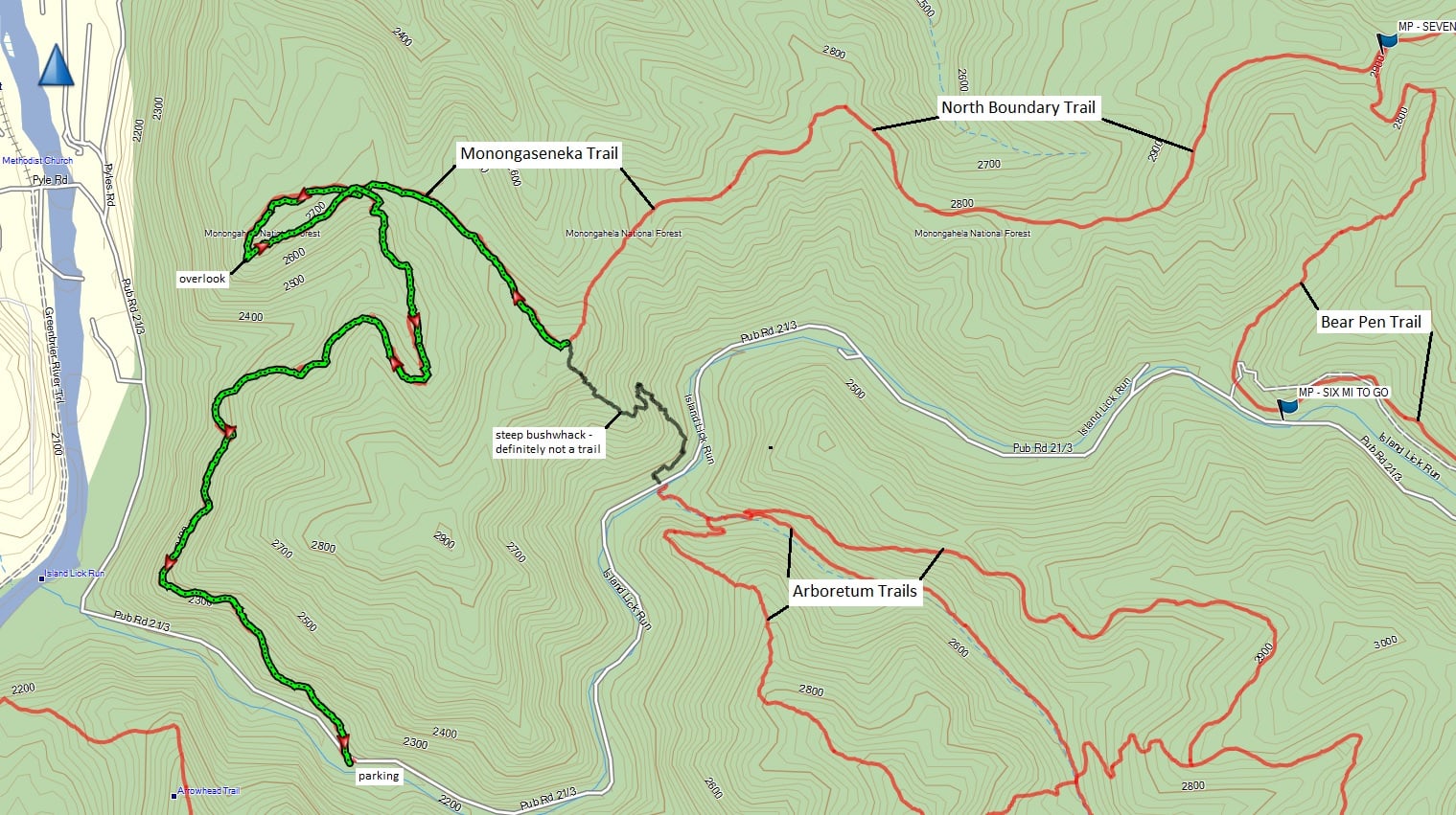
Watoga State Park has many hiking trails to choose from that vary wildly in length and difficulty. There is a wide variety of trail choices, so any level hiker will enjoy their time on the Watoga State Park trails. Stay up to date with events and hikes on our dedicated Watoga State Park Hiking Trails Facebook page ![]()
A small list of these trails includes
- Allegheny Trail [H]
Distance: 5.5 miles
Difficulty: Moderate to difficult
Designated as part of a backpack trail system, this trail extends from its northern terminus near Blackwater Falls State Park in Tucker County south to its intersection with the famed Appalachian Trail near the West Virginia-Virginia border in Monroe County. - Ann Bailey Trail [H] [MBX] [XX]
Trail follows the old roadbed across the top of Pyles Mountain and Workman Ridge to the Ann Bailey Lookout Tower. Mountain bikes welcome
Distance: 3 miles
Difficulty: Moderate to difficult - Arrowhead Trail [H]
Not a loop, return by same trail. Trailhead is at Riverside Campground across from the check-in station. The steep trail leading up to the Ann Bailey Lookout Tower offers spectacular views of the Greenbrier River Valley and Little Levels section of Pocahontas County.
Distance: 1 mile
Difficulty: Difficult - Bear Pen Trail
A loop roughly 4.75 miles long can be made of this trail by incorporating the Buck and Doe Trail and the North Boundary Trail into your walk.
Distance: 3 miles
Difficulty: Moderate - Brooks Memorial Arboretum Trails
A separate map for the Arboretum is available at the park office, campground check-in stations and other visitor contact points throughout the park.
Distance: 4.5 miles
Difficulty: Easy to moderate - Buck and Doe Trail
Trailheads are on Bearpen Trail and North Boundary Trail. This trail enables hikes to make a loop of the Bearpen Trail.
Distance: 0.75 miles
Difficulty: Easy - Burnside Ridge Trail
This trail branches from the Ann Bailey Trail about halfway between the Ann Bailey Trailhead and the Ann Bailey Lookout Tower. Trail ends on end of the ridge. Not a loop; must return by same trail. Mountain bikes welcome.
Distance: 3 miles
Difficulty: Moderate - Honeymoon Trail
Trailheads are located by cabin 34 and on the T. M. Cheek Road 0.5 mile south of the T. M. Cheek Overlook.
Distance: 2 miles
Difficulty: Moderate - Jesse’s Cove Trail
Trailhead is in Riverside Campground across from campsite 6. Trail follows the Greenbrier River downstream to the mouth of Rock Run, then follows Rock Run to the top of Workman Ridge, a climb of more than 1,000 feet. Near the top of the ridge is the old Jarvis/Workman Cabin, an original pioneer cabin. The trail ends at the Ann Bailey Trail.
Distance: 2.5 miles
Difficulty: Moderate to difficult - Kennison Run Trail
Trailheads are at Laurel Run Primitive Campground and along the T. M. Cheek Road across from the Honeymoon Trailhead. Not a loop trail. Many creek crossings are encountered so wear sturdy shoes.
Distance: 3.5 miles
Difficulty: moderate to difficult - Lake Trail
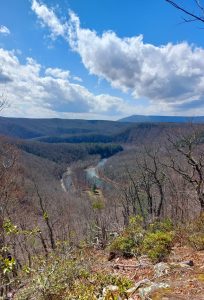
The Monongaseneka Trail leads to a vista that overlooks the Greenbrier River, and the view is always spectacular no matter what time of year - Monongaseneka Trail
Distance: 2.5 miles
Difficulty: Moderate
Trailhead is 0.5 miles above Cabin 2 on the Island Lick Road. The trail climbs the sidehill to a reasonably level grade with views through the trees of the Greenbrier River, then turns into beautiful Jeff Hollow, before climbing the ridge to the top. The trail ends at the North Boundary Trail. - North Boundary Trail
- Pine Run Trail
- T. M. Cheek Trail
- Ten Acre Trail
- South Burnside Trail